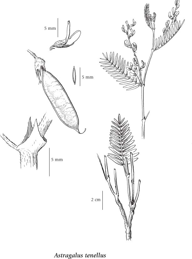
General: Perennial herb from a thick taproot and knotty or short-branched stem-base; stems few to many in bushy clumps, ascending to erect, sometimes sprawling at higher elevations, 20-60 cm tall, branched, short-hairy with appressed, unbranched hairs.
Leaves: Alternate, pinnately compound, 3-8 cm long, the stalks very short or lacking; leaflets 9 to 25, narrowly lanceolate to oblong, rounded at the tip, 0.8-2.5 cm long, finely appressed-hairy below, commonly glabrous above; stipules joined opposite the leaf stalks and clasping the stem, 3-6 mm long, the lowest papery and often blackish, the upper less strongly united.
Flowers: Inflorescence a loose, axillary raceme of 4 to 20 pea-like flowers, the flowers at first ascending, later nodding, the racemes 3-10 cm long on short (1-4 cm) stalks; corollas 6-9 mm long, yellowish-white but sometimes pink-tinged, the keel purple-tipped, the banner slightly longer than the wings, which are 1-2 mm longer than the keel; calyces bell-shaped, appressed-hairy with black or white hairs, 2.5-4 mm long, the awl-shaped teeth 2/3 as long as the tube.
Fruits: Pods, oblong, flattened, 7-18 mm long, drooping from the 1- to 5-mm long stalk, papery-membranous, glabrous, often mottled or stippled, net-veined when mature, 1-chambered.
Mesic to dry grassy slopes and bluffs, sandy and gravelly flats, roadcuts and open forests from the steppe to lower subalpine zones; common in BC south of 57degreeN and east of the Coast-Cascade Mountains; N to S YT, E to MB and S to MN, NE, NM, NV, ID and MT.
The table below shows the species-specific information calculated from original data (BEC database) provided by the BC Ministry of Forests and Range. (Updated August, 2013)